
Time-space Service
TSDB now supports space-time services to help users process spatially geo-related data more efficiently.
Instructions
Current SQL query interface of TSDB supports a variety of spatially geo-related functions, including 2D calculation and spherical calculation. With the strong abilities of such functions, users can easily calculate and analyze spatial geo-related data by using SQL, to mine data value.
Scenario 1: Determine whether a device with a device ID of ABC123 is in a specific area
The following image represents the device position data stored by TSDB: the location information for each device is stored in two fields (field), namely, x_value and y_value, x_value and y_value represent the coordinates of the device in a two-dimensional coordinate system, and licenseID (Tag) is used to represent the device number. The data may be considered as a two-dimensional table (see below), for which space-time services are used by constructing spatial functions. 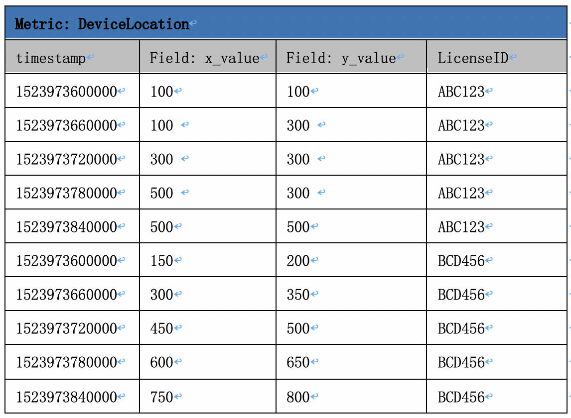
For example: Determine whether a device with a device ID of ABC123 is in a specific area (excluding boundaries); and assume the area is a quadrilateral surrounded by four points, namely, (200, 200), (400, 200), (400, 400) and (200, 400).
SQL statement:
select * from DeviceLocation where ST_Contains(ST_GeometryFromText('POLYGON ((200 200,400 200,400 400,200 400,200 200))'), ST_Point(x_value,y_value)) and LicenseID = ‘ABC123’
Return to get the following data to prove that the device with the device ID of ABC123 is in the specified area at the time of 1523973720000. 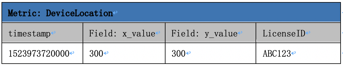 ~~~~
~~~~
Scenario 2: Calculate whether a vehicle passes an area within a certain radius centered on a certain point in the moving
TSDB's space-time service also supports spherical distance calculation. Vehicle location and trajectory are usually located by GPS information, so the real trajectory needs to be calculated by spherical calculation. Referring to the example above, we can replace the x_value and y_value in the example above with the actual longitude and latitude to indicate actual location of the vehicle: 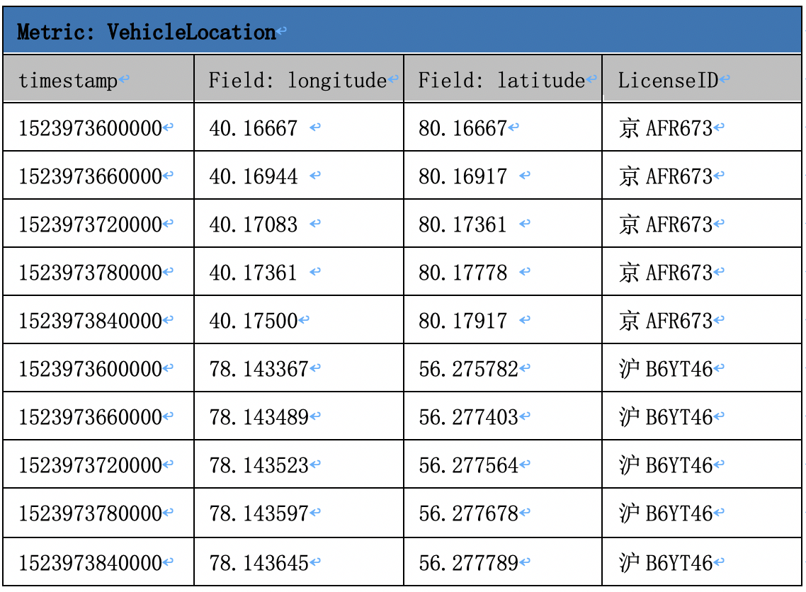
For example: Calculate whether a vehicle passes an area within a radius of 200m centered on a point (40.17222, 80.175) in the moving. SQL statement:
select * from VehicleLocation where LicenseID=’BJAFR673’and ST_Distance(to_spherical_geography(ST_Point(longitude, latitude)),to_spherical_geography(ST_Point(40.17222, 80.175))) <= 200
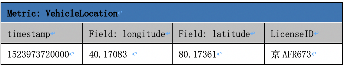
Return to get the following data to prove that the vehicle with the license ID Jing AFR673 passes the specified area at the time of 1523973720000.
Actual Application
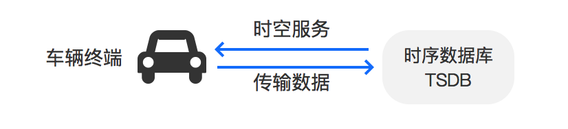
Vehicle Monitoring
[^_^]:
	1. * Required. This section is a three-level task, and three-level task is only required in Baidu AI Cloud Documentation.
	2. Application scenario, precondition and notes may be written.
	3. See Markdown cheat sheet if you have no idea of links. Links include: in-page links, inter-page links, other product links and image links.
	4. Results that can be viewed must be given in the last step.
Use the Time Series Database (TSDB) to store time and space data. TSDB can monitor the real-time current driving route of the vehicle with the help of space-time services. Besides, it can give a timely alarm in exceptional circumstances, such as the vehicle being off the established route, and can view history driving tracks of the vehicle when needed. In the scenario of maintenance car operation, use the TSDB to determine whether the maintenance car is operating in the specified area, whether the maintenance car is driving off the scheduled track, while identifying which rescue vehicle is the nearest to a site, to realize the overall optimization and control of the vehicle.
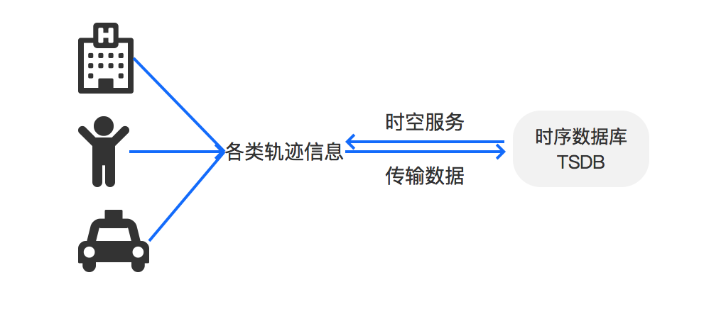
Track Analysis
Use the Time Series Database (TSDB) to store time and space data. TSDB can calculate and analyze the relationship between various types of tracks with the help of space-time services, for example, analyzing and summarizing the hot spots where the crowd is most densely gathered, the time periods at which the most congestion takes place on a particular road, and whether exceptional people and vehicles enter a particular area. Track analysis can be adopted in a wide variety of business scenarios, such as community safety, on-demand location (e.g. office buildings, hospitals, and shopping malls), and traffic diversion.
Reference to Space-time Service Functions
For a reference to the use of SQL statements, see Support SQL Query.
Constructing Functions of Space-time Services
- ST_Point
Statement
Geometry ST_Point (double X, double Y)Function
Return a geometry (Geometry) object of a point (Point) type based on the specified coordinate value (X, Y).
Example
ST_Point(1.0,2.0)Return a geometry (Geometry) object of a point (Point) type with an x-coordinate of 1.0 and a y-coordinate of 2.0.
- ST_LineFromText
Statement
Geometry ST_LineFromText (varchar WKT)Function
Return a geometry (Geometry) object of a linestring (LineString) type from a string expression of Well-Known Text (WKT).
Example
ST_LineFromText('LINESTRING(1.0 1.5,1.0 0.5)') Return a geometry (Geometry) object of a linestring (LineString) type with a starting point (1.0,1.5) and an end point of (1.0,0.5).
- ST_Polygon
Statement Geometry ST_Polygon (varchar WKT) Function
Return a geometry (Geometry) object of a polygon (Polygon) type from a string expression of Well-Known Text (WKT).
Example
ST_Polygon('POLYGON ((1 1,1 4,4 4,4 1))') Return a geometry (Geometry) object of a polygon (Polygon) type defined by points (1, 1), (1, 4), (4, 4), and (4, 1).
- ST_GeometryFromText
Statement
Geometry ST_GeometryFromText (varchar WKT)Function
Return a geometry (Geometry) object from a string expression of Well-Known Text (WKT).
Example
ST_GeometryFromText('POLYGON ((0 0,1 0,1 1,0 1,0 0))') Return a geometry (Geometry) object of a polygon (Polygon) type defined by points (0, 0), (0, 1), (1, 1), and (1, 0).
- to_spherical_geography
Statement
SphericalGeography to_spherical_geography (Geometry geometry)Function
Convert a geometry (Geometry) object to a spherical geography (SphericalGeography) object.
Example
to_spherical_geography(ST_Point(40.172, 80.175))Returns a spherical geography object that identifies the point at 40.172 degrees east longitude and 80.175 degrees north latitude on the earth. -180, 0 is West Longitude, 0, 180 is East Longitude, -90, 0 is South Latitude, and 0, 90 is North Latitude.
Relationship Function of Space-time Services
- ST_Contains
Statement
boolean ST_Contains (Geometry A, Geometry B)Function
If no point in Geometry B is contained in Geometry A, and at least one point inside Geometry B is contained inside Geometry A, return true, otherwise, return false.
Example
ST_Contains(ST_Polygon('POLYGON ((0 0,1 0,1 1,0 1))'), ST_Point(0.5,0.5))=truePoint (0.5, 0.5) falls completely within a polygon defined by points (0, 0), (0, 1), (1, 1), (1, 0), then return true.
- ST_Equals
Statement
boolean ST_Equals(Geometry A, Geometry B)Function
If a geometry (Geometry) object A and a geometry (Geometry) object B indicate the same object, return true, otherwise, return false.
Example
ST_Equals(ST_GeometryFromText('POLYGON ((1 1, 1 3, 3 3, 3 1))'), ST_GeometryFromText('POLYGON ((3 3,3 1,1 1,1 3))')=trueAs the two polygons completely overlap, return true.
- ST_Intersects
Statement
boolean ST_Intersects (Geometry A, Geometry B)Function
If a geometry (Geometry) object A and a geometry (Geometry) object B intersect in two-dimensional space, return true, otherwise, return false.
Example
ST_Intersects(ST_GeometryFromText('POLYGON((1 1, 1 3, 3 3, 3 1))'), ST_GeometryFromText('POLYGON ((4 4, 4 5, 5 5, 5 4))'))=falseAs two rectangles do not intersect, return false.
- ST_Overlaps
Statement
boolean ST_Overlaps (Geometry A, Geometry B)Function
If a geometry (Geometry) object A and a geometry (Geometry) object B partially overlap, and one does not completely contain the other, return true, otherwise, return false.
Example
ST_Overlaps(ST_GeometryFromText('POLYGON ((1 1, 1 4, 4 4, 4 1))'), ST_GeometryFromText('LINESTRING (1 1, 4 4)'))=falseSince a line with the starting point (1, 1) and the end point (4, 4) is fully contained in a polygon defined by points (1, 1), (1, 4), (4, 4), (4, 1), even the two intersect, ST_Overlaps return false.
Access Functions of Space-time Services
- ST_Area
Statement
double ST_Area (Geometry A)Function
Return an area of a geometry (Geometry) object A of a polygon (Polygon) type in two-dimensional space.
Example
ST_Area(ST_GeometryFromText('POLYGON ((2 2, 2 6, 6 6, 6 2))'))=16.0Return an area of 16.0 of a polygon defined by points (2, 2), (2, 6), (6, 6), and (6, 2).
- ST_Area
Statement
double ST_Area (SphericalGeometry A)Function
Return an area of a geometry (Geometry) object A of a polygon (Polygon) type on the Earth's sphere.
Example
ST_Area(to_spherical_geography(ST_Polygon('POLYGON ((0 0,0 90,90 0))')))=6.375825913974858E13Return a spherical area of 6.375825913974858E13 square meters of a polygon defined by points (0, 0), (0, 90), and (90, 0) on the Earth's sphere. The Earth's radius herein is 6371.01 km.
- ST_Distance
Statement
double ST_Distance (Geometry A, Geometry B)Function
Return the shortest Cartesian distance of a geometry (Geometry) object A and a geometry (Geometry) object B in two-dimensional space.
Example
ST_Distance(ST_Point(50, 100), ST_Point(150, 150))= 111.80339887498948Return the shortest Cartesian distance of 111.80339887498948 between point (50, 100) and point (150, 150).
- ST_Distance
Statement
double ST_Distance (SphericalGeometry A, SphericalGeometry B)Function
Return the shortest distance with units as meters of spherical geometry (SphericalGeometry) object A and spherical geometry (SphericalGeometry) object B on the Earth's sphere.
Example
ST_Distance(to_spherical_geography(ST_Point(40.175, 80.175)), to_spherical_geography(ST_Point(40.5, 80.5)))= 36643.77019025462Return a spherical distance of 36643.77019025462 m between point (40.175, 80.175) and point (40.5, 80.5) on Earth. The Earth's radius herein is 6371.01 km.
- ST_Length
Statement
double ST_Length (LineString A)Function
Return the length of a geometry (Geometry) object A of a linestring (LineString) type in two-dimensional space.
Example
ST_Length(ST_GeometryFromText('LINESTRING (0 0, 2 2)'))= 2.8284271247461903Return the length of 2.8284271247461903 of a line with the starting point (0, 0) and the end point (2, 2).
- ST_X
Statement
double ST_X (Point A)Function
Return an x-coordinate of a geometry (Geometry) object A of a point (Point) type.
Example
ST_X(ST_GeometryFromText('POINT (1 2)'))=1.0Return the x-coordinate of the point (1, 2) as 1.0.
- ST_Y
Statement
double ST_Y (Point A)Function
Return a y-coordinate of a geometry (Geometry) object A of a point (Point) type.
Example
ST_Y(ST_GeometryFromText('POINT (1 2)'))=2.0Return the y-coordinate of the point (1, 2) as 2.0.